The steepest funicular in the world and a thrilling ridge walk that makes you feel like a real hiker in under three hours. Plan your Stoos Ridge Hike in Switzerland with this complete guide: how to get there, trail details, difficulty, and the absolute best views along the ridge.

If you want an easy hike in Switzerland that still looks epic, then the Stoos Ridge Hike is it. Suspended above Lake Lucerne, this ridge walk strings together panoramic views, a trail maintained to Swiss-standards perfection, and just enough stair-stepping to make you feel accomplished (or at least I did!).
It’s also absurdly accessible: a funicular and a chairlift, and suddenly you’re on the ridge. In this guide, I’ll break down how to get there, which version of the trail to choose, what to expect along the way, and the practical details you’ll be glad someone told you before lacing up.
- If you’re planning a bigger trip, check out my guide to the 10 best hikes in Switzerland for more trails worth adding to your list.
Stoos Ridge Hike Quick Stats
Let's get the basics first.
Point-to-Point (Klingenstock → Fronalpstock with chairlifts)
- Distance: ~4.5 km (~2.8 miles)
- Difficulty: Easy (safe and family-friendly, it just requires stamina)
- Starting Point (Klingenstock lift top): ~1,935 m (~6,348 feet)
- Finishing Point (Fronalpstock lift top): ~1,922 m (~6,302 feet)
- Highest Point: ~2,017 m (~6,617 feet)
- Total Elevation Gain: ~282 m (~925 feet)
- Total Ascent: ~380 m (~1,247 feet, all climbs added)
- Total Descent: ~400 m (~1,312 feet, all downhills added)
- Time to Complete: 2 hours
- Route on AllTrails.com
Full Loop (without chairlifts, from Stoos village)
- Distance: ~12,5 km (~7.8 miles)
- Difficulty: Moderate-hard (steeper, much longer)
- Starting/Finishing Point (Stoos village): ~1,300 m (~4,265 feet)
- Highest Point: ~2,017 m (~6,617 feet)
- Total Elevation Gain: ~717 m (~2,352 feet)
- Total Ascent: ~980 m (~3,215 feet, all climbs added)
- Total Descent: ~980 m (~3,215 feet, all downhills added)
- Time to Complete: 5–6 hours
- Route on AllTrails.com
Stoos Ridge Hiking Map
Before setting out, it helps to see how the ridge connects Stoos village, the funicular, the chairlifts, and the trail itself. This map shows the full picture, like where you’ll start, how the lifts line up, and how the point-to-point route compares with the full loop.

Where Is the Stoos Ridge Hike located?
The Stoos Ridge Hike sits in central Switzerland, high above Lake Lucerne in the canton of Schwyz. The trail runs between two small summits, Klingenstock and Fronalpstock, with the village of Stoos tucked just below. It’s only about 50 minutes from Lucerne or 90 minutes from Zurich, which makes it an easy day trip but also a solid base if you want to overnight in the mountains.
Stoos itself is a car-free village, reached only by funicular or cable car. Once you’re up, the ridge dominates the skyline: a narrow, undulating path with constant views of the lake and the surrounding Alps.
How to Get to the Stoos Ridge Hike
By Public Tranport
From Lucerne, take a train to the town of Schwyz, the capital of the surrounding canton and the transport hub for Stoos. The ride takes about 45 minutes. From Schwyz train station, local buses (20 minutes) run directly to the Stoosbahn valley station, where the funicular begins. From there, it’s just a short ride up to Stoos village. Total travel time is around 1 hour 15 minutes.
Direct trains also connect Zurich with Schwyz in about 55 minutes. From the station, catch the bus to the Stoosbahn valley station (20 minutes). Add in the funicular ride, and you’ll be in Stoos in roughly 1 hour 45 minutes.
By Car
If you’re driving, set your GPS to the Stoosbahn valley station near Schwyz. From Lucerne it’s about 50 minutes by car, and from Zurich just over an hour. There’s a big car park right in front of the funicular, with plenty of space at any time.
The Stoosbahn Funicular
The funicular to Stoos is part of the experience. Opened in 2017, it’s officially the steepest funicular in the world, conquering gradients of up to 110%. The ride takes only a few minutes and saves you nearly 750 meters of uphill grind. Tickets are available at the station or online on Stoos.ch, and you can bundle them with the Klingenstock and Fronalpstock chairlift rides if you’re planning the point-to-point version of the ridge. This bundle should cost around CHF 46–60 for adults depending on season. Children, Swiss Travel Pass, and half-fare card holders pay less.
The Funicular runs year-round, and in summer, the first ride is usually around 7:00 am and the last down around 11:30 pm (times are extended because Stoos is car-free and locals rely on it).


Trail Options
There are two main ways to tackle the Stoos Ridge Hike. Which one you choose depends on how much time and energy you have, and how much climbing you actually want to do.
Point-to-Point (Klingenstock to Fronalpstock)
This is the most popular option and the one most people mean when they talk about the Stoos Ridge Hike. You ride the chairlift up to Klingenstock, walk the ridge, and descend by chairlift from Fronalpstock. The hike itself is about 4.5 km and takes 2 to 2.5 hours. It’s the easier version, there are no technical difficulties but still involves several ups and downs along the ridge.
Both chairlifts operates roughly 9:00 am – 4:00 pm, mid-June through late October.
Full Loop (skipping chairlifts, harder option)
If you want the full workout version, skip the chairlifts. Start in Stoos village (~1,300 m), climb up to Klingenstock on foot, walk the ridge to Fronalpstock, and descend back to Stoos without using lifts. That loop is about 13 km with ~900 m total ascent and descent. Plan on 5–6 hours of hiking.
The lower part of the loop winds through forest and pasture, so you don’t get those big panoramas until you break onto the ridge. You must also keep in mind that there’s no food or drink until you reach Fronalpstock.
Klingenstock to Fronalpstock Hike Overview
Chairlift and Best Viewpoints
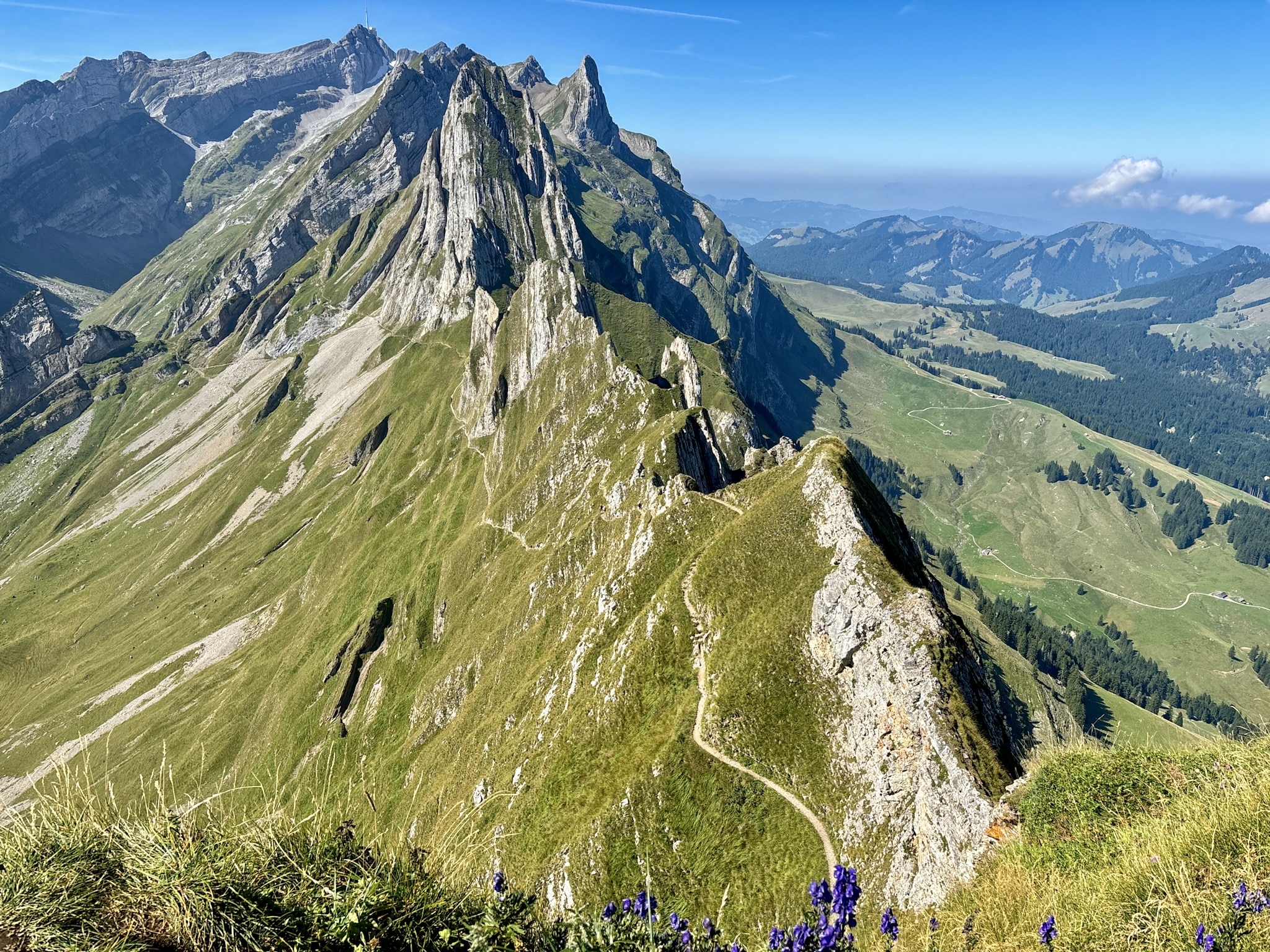
From Stoos village it’s a 10-minute walk to the Klingenstock chairlift. The chairlift is open-air, which can be thrilling or terrifying depending on how you feel about heights. At the top (1,935 m), the ridge trail begins immediately, you step straight into the view, with Lake Lucerne already spilling out beneath you.
The trail is wide and well-prepared, but it undulates: short climbs and descents stacked one after another. Families can do it, but it’s not a flat stroll, you’ll absolutely feel it in your legs.
To your right, Lake Lucerne cuts deep into the valley; to your left, the sharp twin peaks of the Mythen stand out. Midway you can make a quick detour up to Huserstock (1,904 m), a short climb for an extra panoramic angle that most people skip.


About three-quarters in you’ll hit the best viewpoint, the so-called “Stairway to Heaven”. It’s the most photographed point, but in reality every section of the ridge offers the same drama. You really can’t miss it, it’s right on the main path.


Summit and Descent Options
The final climb to Fronalpstock (2,017 m) is the steepest, but also the most rewarding. At the summit you get the full 360°: Lake Lucerne’s arms from above, Pilatus to the west, Rigi to the north, and, on a clear horizon, the snowy line of the Bernese Alps.
Next to the top station is a self-service restaurant. It’s not gourmet, but a plate of rösti or a schnitzel on the terrace with that view does the job.
From here you can descend with the Fronalpstock chairlift, split into two sections down to Stoos. Most hikers take this option, and it’s covered by the combo ticket. If you walk, plan an extra 1.5–2 hours: the descent is steady, punishing on knees, but quiet once the chairlift crowds vanish.


Practical Tips for Hiking Stoos Ridge
- Direction matters: Hike Klingenstock → Fronalpstock. You’ll have the best views in front of you the whole way, and the final climb is steeper but more rewarding.
- Remember that the last chairlift departs at 4pm
- Tickets: if you don’t have a Swiss Travel Pass and are planning to do the classic easy ridge hike, buy the combo ticket (Stoosbahn funicular + both chairlifts). It’s cheaper than paying separately and saves you from queuing twice.
- Food & Water: Don’t rely on the ridge. There’s nothing between the start and Fronalpstock except benches. Bring at least 1 liter of water per person, and either carry snacks or plan to eat at the summit restaurant or back in Stoos.
- Gear: Sturdy shoes are enough, but hiking poles can help with the descents, especially if you skip the chairlift.
- Weather: The ridge is exposed. Fog means no views, rain makes it slippery, and wind can feel amplified. Always check the forecast before heading up.
- Fear of heights: The trail itself is wide and secure, but the chairlifts are open-air. If that’s a problem, you’ll need to hike up from Stoos instead of riding them.
Frequently Asked Questions
Best Time To Do the Stoos Ridge Hike?
Late June to October. That’s when the ridge is snow-free and both chairlifts are in service. July and August have the longest daylight, but also the biggest crowds. September often brings clearer skies and fewer people.
Is The Stoos Ridge Hike Difficult?
The classic 4.4km point-to-point version is relatively easy, and ideal if you're a beginner. The path is wide and secure, with steps on steeper parts. It’s not a flat walk, though: the constant ups and downs mean you need a good level of fitness. This version is also doable for active kids. Small children may struggle with the repeated climbs and descents, so plan extra breaks. The full 12km loop from Stoos, however, is too long and strenuous for younger kids or beginners.
How Much Does the Stoos Ridge Hike Cost?
The hike itself is free, but the lifts aren’t. A combo ticket covering the Stoosbahn funicular and both chairlifts (Klingenstock up, Fronalpstock down) costs around CHF 46–60 for adults depending on season. Children, Swiss Travel Pass, and half-fare card holders pay less. If you hike the loop and skip the lifts, you’ll only need the Stoosbahn ticket.
What About the Swiss Travel Pass?
The Swiss Travel Pass is a nationwide rail pass covering most trains, buses, and boats in Switzerland. It also gives free or discounted rides on many mountain lifts. For Stoos:
- The Stoosbahn funicular is fully covered by the Swiss Travel Pass.
- The chairlifts (Klingenstock and Fronalpstock) are not included, but pass holders usually get a reduced fare.
Where to Stay in Stoos?
Stoos is small, but if you want to turn the ridge hike into an overnight trip, you’ve got options.
I stayed at Stoos Lodge and loved it. It’s in the middle of the village, right in front of the funicular exit (which is nice if you're bringing lots of luggage). It features modern rooms, a big buffet-style breakfast, and even a spa, which makes sense when your legs are wrecked from the loop version of the hike. On rainy days, the spa pool is pretty much the only place in Stoos where people still look happy. For something simpler, there are a few guesthouses and alpine lodges scattered around the village. They’re more basic (think creaky floors and hearty dinners) but cheaper.
If you’d rather day-trip, you don’t have to stay in Stoos at all. The town of Schwyz down in the valley has more hotels and easier train connections, and Lucerne is close enough that plenty of people just commute in for the hike.