Discover the 15 best hikes in the world: a global shortlist of the most beautiful hiking trails chosen for scenery and impact, not suffering.

Try putting together the best hikes in the world and watch how quickly it turns into chaos. Everyone has a trail they’ll defend to the death: the one with the sunrise, the one with the glacier, the one where they nearly twisted an ankle but decided it was “life-changing.” The trick is to strip all that noise away and keep only the trails that deliver something undeniable.
So here it is: fifteen of them. A global lineup of the most beautiful hiking trails in the world, chosen because they look outrageous, feel unforgettable, and don’t require a death wish to enjoy. Call it the shortlist worth arguing over.
Best Hikes in North America
1. Bright Angel Trail – Grand Canyon, USA
Distance: 24 km / 15 mi (to river and back); Elevation: ~1,340 m / 4,400 ft; Duration: 8–12 hrs;

The Grand Canyon looks unreal from the rim, and Bright Angel proves it’s real by pulling you inside. The trail drops 4,400 feet from Grand Canyon Village to the Colorado River, about 15 miles round trip, though many turn at Indian Garden, a nine-mile hike that still feels like time travel through layers of stone.
Switchbacks cut into cliffs the color of rust and sand, each bend a new crash course in geology. Rest houses and seasonal water taps break the descent, but the climb back turns every step into work. Rangers love to remind you: down is optional, up is mandatory.
Spring and fall are the only seasons that make sense. In July, the canyon floor bakes over 100°F. In winter, the rim ices up. The trail itself is wide and well signed, but the numbers don’t lie: 24 kilometers, 1,340 meters down and the same back up.
2. The Narrows – Zion, USA
Distance: up to 26 km / 16 mi; Elevation: ~120 m / 400 ft; Duration: 6–10 hrs (out-and-back) or 1–2 days (top-down);

The trail is a river, no metaphor. For 16 miles the Virgin River cuts through Navajo sandstone, and you walk straight in it. At the narrowest point the walls close to six meters apart and rise hundreds above your head, light bouncing down in ribbons of orange and red.
Depth shifts with the season: sometimes shin-high, sometimes up to your ribs, which is why most hikers turn back around mile five at Big Spring and still feel they’ve seen something unearthly. Elevation gain is modest (under 400 feet), but progress is slow: rocks are slick, currents push back, and every bend seems staged for its own photograph.
Permits are required for the full top-down trek, while the shorter out-and-back needs only nerve and a good pair of water shoes. Late summer to early fall offers the safest conditions.
Zion has a dozen trails, but this one explains itself immediately, as few places let you walk through the landscape instead of beside it.
3. Kalalau Trail – Kauai, Hawaii
Distance: 35 km / 22 mi (full trail) or 13km / 8 mi (up to Hanakāpīʻai Falls) ; Elevation: ~1,800 m / 6,000 ft; Duration: 2 days (full trail) or 4–6 hrs (up toHanakāpīʻai Falls);

Eleven miles along the Na Pali Coast, nothing but ocean on one side and cliffs that seem to rise forever on the other. The Kalalau Trail begins at Ke’e Beach and climbs fast (about 1,800 feet in the first two miles) before settling into a rhythm of ridges and valleys that repeat like a song you can’t get out of your head.
The full trek to Kalalau Beach is a two-day affair, though many stop at Hanakāpīʻai Falls, an eight-mile round trip with a 300-foot waterfall at the end.
This is Hawaii at its most theatrical: red earth, green cliffs, surf pounding below. The trail is official, well-marked, but also muddy and slick year-round. Permits are mandatory beyond Hanakāpīʻai, camping only on the sand at Kalalau. The best months are May through September when rains ease and the Pacific looks painted on.
4. Skyline Trail – Jasper, Canada
Distance: 44 km / 27 mi; Elevation: ~1,400 m / 4,600 ft; Duration: 2–3 days;

The Skyline Trail is Jasper’s crown jewel. Stretching 27 miles from Maligne Lake to Maligne Canyon, it spends nearly half that distance above the tree line. Meadows roll out in every direction, jagged peaks line the horizon, and for long stretches the trail really does feel like it’s hanging above the valley.
It takes two to three days, with 4,600 feet of elevation gain spread across the ridges. Campsites are sensibly spaced, but the 15 miles of exposure above treeline can turn on you fast if weather shifts. This is the Canadian Rockies, so storms hit suddenly, and there’s nowhere to hide.
Most hikers aim for late July through early September, when snow has melted back and wildflowers take over the high meadows. The path is marked and maintained, but it’s not casual, as distance, exposure, and weather keep it serious. Camping permits are mandatory and usually booked months in advance.
5. Plain of Six Glaciers – Banff, Canada
Distance: 14 km / 9 mi; Elevation: ~400 m / 1,300 ft; Duration: 4–6 hrs;

The hike begins with Lake Louise, which looks Photoshopped even in person, and keeps climbing until the crowds thin. From the lakeshore it’s about 9 miles round trip, with 1,300 feet of elevation gain, to reach the overlook where six glaciers spill down in sight at once. The trail is steady, never technical, switchbacks cut through forest before opening into a cirque of ice, rock, and avalanche runout that hums in the heat.
Halfway up, there’s a wooden teahouse from 1927 that still serves pie, soup, and hot chocolate. It feels like a prank to find a café halfway up a mountain, but it’s real, and it’s excellent. Most hikers turn around from there and are back at the lake in five hours. Push another mile to Abbot Pass viewpoint and the panoramas double. The best window is July through September, when the snowfields retreat and the trail is clear.
Best Hikes in South America
6. Torres del Paine W Trek – Chile
Distance: 80 km / 50 mi; Elevation: ~2,700 m / 9,000 ft; Duration: 4–5 days;

The W Trek stitches four valleys into a jagged “W,” each one raising the stakes. The first delivers the granite towers of Paine, spiking straight into sunrise. The second is the French Valley, where avalanches drop on cue from hanging glaciers. The last ends at Grey Glacier, a wall of ice that splinters into blue shards the size of buildings.
The full route runs 50 miles with nearly 9,000 feet of climbing, usually spread over four to five days. Refugios and campsites dot the trail, a surprise in a landscape that otherwise feels like the end of the earth.
Weather is never background here. One hour can be blazing sun, the next a windstorm that shoves you sideways, then rain that comes out of nowhere. High season is December to February, and beds or campsites sell out months ahead. For anyone willing to plan, few treks pack this much drama into a single route.
7. Fitz Roy / Laguna de los Tres – Argentina
Distance: 21 km / 13 mi; Elevation: ~700 m / 2,300 ft; Duration: 8–9 hrs;

El Chaltén is known as Argentina’s trekking capital for a reason. The hike to Laguna de los Tres goes straight from town into Patagonia’s most photographed skyline. It’s a 13-mile round trip with 2,300 feet of climbing, ending at a turquoise lake set beneath the granite walls of Fitz Roy. The final mile is a steep push on loose rock that’ll have you questioning your life choices, until the lake comes into view and resets everything.
Most hikers start early, carry food, and make a full day of it. Eight to nine hours is the standard pace. The trail is signed and straightforward, crowded in summer, but once the forest drops away and the spires fill the horizon, the drama outweighs the foot traffic.
Patagonia has multi-day routes that run deeper into the wilderness, yet this one works in a single day: leave the village in the morning, sit at the base of Fitz Roy by lunch, and walk back into town by nightfall.
8. Salkantay Trek – Peru
Distance: 72 km / 45 mi; Elevation: ~1,830 m / 6,000 ft (highest point 4,650 m / 15,200 ft); Duration: 5 days;

The Inca Trail has the fame, but Salkantay has the drama. Seventy-two kilometers over five days, climbing to the Salkantay Pass at 15,200 feet before dropping into cloud forest that smells of orchids and wet stone. Elevation gain totals more than 6,000 feet, and the contrast is absurd: snow and ice in the morning, coffee plants and parrots by afternoon.
Camps are scattered sensibly, some with domes or cabins, others barebones, and guides keep the logistics easy. Permits aren’t the headache they are on the Inca Trail, which means you can book weeks ahead instead of months. Most treks finish with a train into Aguas Calientes and the final climb to Machu Picchu.
What stays with you isn’t the ruins at the end, though, but the pass itself, and the glaciers hanging above a trail that feels carved into the spine of the Andes.
Best Hikes in Europe
9. Tour du Mont Blanc – France, Italy & Switzerland
Distance: 170 km / 105 mi; Elevation: ~10,000 m / 32,800 ft; Duration: 10–12 days;

One peak, three countries, 105 miles of trail curling around it like a ribbon. The Tour du Mont Blanc takes about ten days if you walk the whole circuit, climbing a cumulative 32,000 feet—up to passes with names that sound like battle honors, then down into villages with wine and cheese at the ready.
Refuges dot the route, some no more than stone huts, others serving three-course dinners. Most hikers start in Chamonix or Courmayeur, clockwise or counter, and quickly lose track of borders; the Alps don’t care where France ends and Italy begins. July and August bring wildflowers, September quiets the crowds.
The tour is less about a single summit moment than the rhythm of alpine life strung together: cowbells in the morning, glaciers by afternoon.
10. Alta Via 1 – Dolomites, Italy
Distance: 120 km / 75 mi; Elevation: ~6,100 m / 20,000 ft; Duration: 7–10 days;

Alta Via 1 opens with Lago di Braies, green water you’ve already seen on postcards, and keeps going for 75 miles until the town of Belluno. Along the way the trail plays greatest hits: the Tofane above Cortina, the spindly towers at Cinque Torri, the hulking mass of Pelmo, the Civetta looming like a fortress. Elevation gain totals around 20,000 feet, usually spread over a week to ten days.
Mountain huts mark the rhythm with wood beams, hot strudel, glasses of wine balanced against views that feel staged. July and August fill every bunk; September clears the crowds and risks the first snow.
Long treks often test patience, but this one flatters it, handing you the Dolomites in chapters too good to skip.
11. Laugavegur Trail – Iceland
Distance: 55 km / 34 mi; Elevation: ~1,500 m / 5,000 ft; Duration: 4 days (6 days with Fimmvörðuháls);

Fifty-five kilometers through a landscape that never agrees on what it wants to be. The Laugavegur begins in Landmannalaugar with rhyolite hills striped in colors no crayon box would dare, crosses steaming vents and black deserts, then finishes at Þórsmörk in a valley of birch and glacier-fed rivers. Most take four days, each one a different planet.
Elevation gain adds up to about 5,000 feet, though the numbers matter less than the weather. Snow can linger into July, storms roll in without notice, and huts along the way book out months in advance. Some hikers tack on the Fimmvörðuháls Pass to finish by Skógar and its waterfall curtain, stretching the trek to six days.
Few trails change character this fast, with rainbow mountains at breakfast, obsidian fields by lunch, glaciers by evening. It’s Iceland condensed.
12. Hardergrat Ridge & Augstmatthorn – Switzerland
Distance: 24 km / 15 mi (full ridge) or ~16 km / 10 mi (to Augstmatthorn); Elevation: ~3,000 m / 10,000 ft; Duration: 8–12 hrs;

A ridge so thin it feels like someone drew a line across the Alps and dared you to follow it. The Hardergrat stretches for 15 miles above Lake Brienz, climbing nearly 10,000 feet in all, but most hikers aim for the section to Augstmatthorn—about 10 miles, still enough to test legs and balance. On clear days the views swing from turquoise water to the Jungfrau massif, glaciers stacked like armor in the distance.
The trail is official, well marked, and brutally exposed: no shade, no easy exits, which is why most people start at dawn from Harder Kulm and time their arrival with the ibex that wander the ridgeline. Best months are July through September when snow is gone and daylight lingers.
Plenty of hikes show you the Alps, but we selected this one because it makes you feel like you’re walking their spine.
Best Hikes Asia & Oceania
13. Tiger Leaping Gorge – China
Distance: 22–29 km / 14–18 mi; Elevation: ~2,600 m / 8,500 ft cumulative; Duration: 2 days;

A trail carved above the Yangtze, with cliffs so steep you keep checking your balance even when the path is wide. The classic route runs about 14 miles between Qiaotou and Walnut Garden, but with side trips you can stretch it closer to 20. Elevation gain tops 8,000 feet in total, with switchbacks that climb into cornfields, then terraces of stone that hang above the river like balconies.
Most hikers take two days, overnighting in guesthouses perched on ledges where you eat noodles with a view straight into the gorge. Autumn and spring are best, when skies clear and the heat doesn’t press so hard. The trail is marked, the guesthouses simple, and the sense of scale almost ridiculous: the Yangtze roaring thousands of feet below, the Jade Dragon Snow Mountain looming white above.
14. Annapurna Panorama Trek – Nepal
Distance: ~65 km / 40 mi; Elevation: ~3,000 m / 10,000 ft cumulative; Duration: 5–7 days;

Not every Himalayan hike has to gamble with oxygen. The Panorama Trek keeps things human, looping five to seven days through villages and rhododendron forests with the Annapurna range always in sight. The route from Nayapul to Ghorepani and Ghandruk covers about 40 miles, climbing close to 10,000 feet, with teahouses spaced so neatly it feels like someone planned them for your legs.
The pre-dawn climb up Poon Hill is the headline: 3,200 steps in the dark, then sunrise burning across Annapurna South, Machapuchare, Dhaulagiri. Most walkers take it slow, three to six hours a day, stopping for dal bhat or ginger tea in villages. October through April is clear and dry; summer monsoon makes a swamp of the trail.
It’s a trek that delivers the scale of the Himalaya without demanding devotion to misery.
15. Tongariro Alpine Crossing – New Zealand
Distance: 19 km / 12 mi; Elevation: ~800 m / 2,600 ft; Duration: 6–8 hrs;

One day, 12 miles, and a route that was borrowed from science fiction. The Tongariro Alpine Crossing climbs nearly 2,600 feet from Mangatepopo to Ketetahi, cresting the South Crater before tilting toward Red Crater, still steaming, then dropping past the Emerald Lakes: small, acid-bright, impossible to photograph without making them look fake.
Most hikers take six to eight hours. Weather flips without warning, meaning you get blue skies one minute, and wind that feels weaponized the next. Summer (December to March) is safest, when the trail is clear of snow and shuttle buses link the trailheads.
New Zealand has other alpine walks, but none pack this much variety into a single day. Lava flows, craters, lakes, ridges, all strung together like scenes from a film that forgot to pick a genre.
Other Epic Hikes Worth Mentioning
Some trails didn’t make the main fifteen, not because they lacked beauty, but because the cut was brutal. Leave them off entirely and the list feels incomplete, so consider these the bonus round.
- Huayhuash Trek – Peru: Ten days, high passes, glacial lakes the color of gems. Remote, demanding, unforgettable.
- Kungsleden – Sweden: The King’s Trail through Lapland, weeks of tundra and midnight sun. A pilgrimage for those who like silence as scenery.
- Trolltunga – Norway: A 17-mile day with 2,900 feet of gain to a rock ledge hanging above the Hardangerfjord. Instagram made it famous; the view justifies the hype.
- Tre Cime di Lavaredo and Cadini di Misurina – Italy: A 10–20 mile loop around the three spires of the Dolomites plus a detour to the nearby Cadini di Misurina. Crowded, yes, but cinematic enough to forgive it.
- Oeschinensee Panorama Trail – Switzerland: Nine miles of alpine theater circling a turquoise lake beneath cliffs that look borrowed from fantasy.
- Carros de Foc – Pyrenees, Spain: A hut-to-hut circuit in Aigüestortes, 40 miles linking high passes and glacial lakes. A condensed Pyrenees greatest hits reel.
Famous Hikes We Excluded (and Why)
Not every headline trail deserves a ticket. Some are dangerous for the sake of it, some famous mostly because people like to say they went and survived. A few of the usual suspects:
- Everest Base Camp – Nepal: Altitude sickness isn’t a badge of honor. The views are immense, but the risk and crowds outweigh the reward for most travelers.
- Angel’s Landing – Utah, USA: A sandstone spine with chains bolted in. Thrilling, yes, but one slip ends the story. Zion has safer beauty.
- Appalachian Trail – USA: Legendary length, less legendary scenery. Too many filler miles to sit beside the world’s greats.
- K2 Base Camp – Pakistan: Remote, dangerous, and brutally demanding. Best left to climbers chasing summits, not hikers chasing views.
Excluding them wasn’t a dismissal, it was a reminder that beauty and not bravado set the bar here.
Keep reading:

Five Lakes Hike, Zermatt: A Complete Trail Walkthrough
Explore the Zermatt Five Lakes Hike with this practical trail guide: route options, lift details, best spots, and what to expect at each lake.[dssb_sharing_buttons icon_placement="icon" icon_width="fixed" alignment="left" icon_color="#000000" use_custom_icon_size="on"...
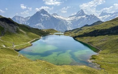
Bachalpsee & Faulhorn Hike from Grindelwald First, Switzerland
A complete guide with trail times, stats, and tips for hiking from Grindelwald to Bachalpsee and Faulhorn—easy lake walk or full climb, the choice is yours.[dssb_sharing_buttons icon_placement="icon" icon_width="fixed" alignment="left" icon_color="#000000"...
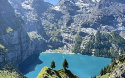
Oeschinensee Hike Guide: Panorama Loop, Best Lake Views
The Oeschinensee Panorama Hike is the one loop to do in Switzerland. Here's a complete guide with trail tips, viewpoints, and the lake scenes you came here for.[dssb_sharing_buttons icon_placement="icon" icon_width="fixed" alignment="left" icon_color="#000000"...