A complete guide with trail times, stats, and tips for hiking from Grindelwald to Bachalpsee and Faulhorn—easy lake walk or full climb, the choice is yours.

The Bachalpsee & Faulhorn hike is one of Grindelwald’s classics because it works on two levels. First, the easy walk to Lake Bachalpsee: wide path, gentle incline, cows everywhere, the kind of trail even kids and strollers can manage. Then, for anyone with stronger legs, the climb continues up to Faulhorn, where a 19th-century hut waits on the summit. Same starting point, two very different hikes.
This guide explains how to do both. You’ll find the basics: where Grindelwald, Bachalpsee and Faulhorn are, how to reach them, and the stats for each version of the trail, right before we go step by step through the route itself. There’s also the optional detour to the First Cliff Walk, plus advice on where to stay if you’re planning more than one hike in the region.
- Thinking of exploring more trails around here? You’ll love my guide to the 10 best hikes in Switzerland
Quick Stats for the Bachalpsee & Faulhorn Hike
As previously mentioned, there are two main hikes here—most families stop at Bachalpsee, but the trail goes on up to Faulhorn mountain hut.
Grindelwald ‘First’–Bachalpsee (Lake Only)
- Type: Point-to-point
- Distance: 3,1 km / 1.9 miles one way (6,2 km / 3.9 miles return).
- Hiking time: 50–60 minutes each way.
- Elevation gain: about 220 m / 720 ft
- Difficulty: easy. Suitable for families, and strollers make it most of the way.
- AllTrails map
Grindelwald ‘First’–Bachalpsee–Faulhorn (Full Route)
- Type: Point-to-point
- Distance: about 6 km / 3.7 miles one way (12 km / 7.4 miles return).
- Hiking time: 2 hours each way.
- Elevation gain: around 600 m / 1,970 ft
- Difficulty: moderate. After Bachalpsee, the path is still clear and wide, but the climb is steep and long.
- AllTrails map
‘First’–Bachalpsee–Faulhorn Hiking Map
Visual reference helps more than numbers alone. Here’s the full trail plotted out, starting in Grindelwald:

Where Exactly Are Grindelwald, Bachalpsee, and Faulhorn?
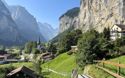
Grindelwald is the gateway town. Bachalpsee is the postcard lake you reach in under an hour. Faulhorn is the historic hut perched above it, where the easy stroll suddenly turns into a climb. Here’s how to reach each one:
How to Get to Grindelwald
The village sits in the Jungfrau region of the Bernese Oberland, about 35 minutes by train from Interlaken. Trains leave twice an hour, and the station is right in the center of town. Driving takes about the same time, but summer parking near the gondola goes fast.
From the Grindelwald train station, it’s a 10–12 minute uphill walk to the Firstbahn or ‘First’ gondola, your launch point for the hike.
How to Get to Bachalpsee
The ‘First’ gondola is no quick hop, as it runs in three sections and takes a full 25 minutes to reach the top. A return ticket costs around CHF 68 for adults, half-price with a Swiss Travel Pass or Half Fare Card. Summer hours are roughly 8:30 a.m. to 5:30 p.m., with slight seasonal shifts.
From the top station, the walk to Lake Bachalpsee is 3 km, usually 50–60 minutes. The path is wide and smooth, with just a last push before the lake itself. Families bring strollers and get almost to the end.
How to Get to Faulhorn
Beyond Lake Bachalpsee, the trail keeps rising toward Faulhorn, adding about 4 km and 600 vertical meters to the overall hike. Count on two hours of steady climbing. It’s not exposed or technical, just relentless. At the summit, the Berghotel Faulhorn, built in 1830, waits with hot food, dorm beds, and wide-open views. Full stats for this longer option are in the next section.

The Hike Detailed Experience
Grindelwald First Gondola & Cliff Walk Platform
The Firstbahn gondola is quite the adventure itself. For 25 minutes, as you rise, Grindelwald shrinks into a toy village and the north face of the Eiger looms closer. At the top station you’ll find the First Cliff Walk, a metal catwalk bolted to the rock with a see-through floor and a viewing platform that hangs over the void. Some people love it, others look straight ahead and grip the rail, but it’s a good add-on before or after the hike.


Hiking to Bachalpsee Lake
From the gondola station, the path to Lake Bachalpsee is clear: 3.1 km (1.9 miles) one way, usually under an hour. The trail is wide, mostly gravel, and climbs gently through pastures where cows wander freely—bells included. Strollers make it nearly to the end, though the final push is better on foot.
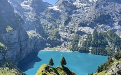
The lake itself is a glacial tarn, stretched out on a plateau at 2,265 meters. A narrow strip of land cuts across the middle, making it look like two separate lakes when you first arrive. The classic viewpoint is from the little rise on the other side of the lake. From there, the peaks of Wetterhorn and Schreckhorn line up behind the water, and if you’re lucky you’ll catch a full reflection. Morning can be misty here, sharper light and clearer reflections usually come in the afternoon.
Bathing isn’t advised, and because of grazing cows, it can be tricky to find a perfectly clean patch of grass for a picnic. Also, there are no huts at the lake, just the view.


From Bachalpsee to Faulhorn
Most visitors stop at Bachalpsee. If you continue, the mood changes quickly. The trail to Faulhorn stretches another 4 km (2.5 miles) with about 600 m (1,970 ft) of climbing. It’s not technical, but it takes stamina. Marmots sometimes appear along the way, a distraction while your legs complain.
At the summit, the Berghotel Faulhorn (built in 1830) is waiting. It’s one of Switzerland’s oldest mountain hotels, a creaky wooden hut that feels like it hasn’t changed in a century, except now it serves rösti, soup, and beer to grateful hikers. Dorm-style beds are available if you book ahead. The real prize, though, is the view: from the terrace you get the Eiger and Wetterhorn in one direction, and in the other, the turquoise shimmer of Lake Brienz far below.


The Way Back Down
Most hikers return the same way they came: back from Faulhorn to Bachalpsee, then on to the gondola at First. The descent is long, but straightforward. Knees take more punishment than lungs here, so hiking poles are handy.
Passing the lake a second time is a bonus: in late afternoon the light is usually sharper, with peaks reflected more clearly on the water than in the morning. Once back at the gondola, the 25-minute ride down to Grindelwald feels like a well-earned rest.


Where to Stay for the Bachalpsee & Faulhorn Hike
If your main goal is this specific hike, Grindelwald is the obvious base. Staying in town means you can walk to the gondola in the morning without stressing about train timetables, and you’ll have time to tack on other activities from the First lift system—zipline, mountain carts, or simply another hike the next day. Hotels here lean toward chalet style, and summer rates match the view: high.
For a broader trip, Interlaken or something in that area makes more sense. From there, you can reach Grindelwald in about 35 minutes by train, but you’ll also be within easy range of Lauterbrunnen, Oeschinensee, and even the Augstmatthorn ridge hike above Lake Brienz. It’s busier, less alpine in atmosphere, but more practical if you’re stacking multiple day hikes into one trip.

Essential Hiking Tips
- Buy your gondola ticket online: Queues can be long on summer mornings; an online ticket saves you time and stress. A return ticket from Grindelwald to First costs around CHF 68. Holders of the Swiss Travel Pass or Half Fare Card pay about half.
- Stock up in Grindelwald, not at the lake: There are some expensive cafés and shops at the gondola top station, but once you leave for Bachalpsee there’s nothing until the Faulhorn hut. Bring plenty of snacks and water.
- Check the webcams before you go: the First webcams are your friend. You can see real-time conditions before paying for the gondola. Locals check them constantly because Bachalpsee often sits in cloud cover, especially in the morning. If the webcam shows fog, wait it out in Grindelwald or plan for later in the day.
- Gear is simple, but shoes matter: The trail is wide and well-marked. You don’t need alpine kit, but do wear proper hiking shoes. Poles help on the descent from Faulhorn. Also, a light jacket is smart even in summer, as the lake sits at 2,265 m and weather shifts quickly.
Frequently Asked Questions
How long is the hike to Bachalpsee Lake?
Starting from the Grindelwald Firstbahn gondola top station, it’s about 50–60 minutes each way. The path is 3.1 km (1.9 miles) long, gains about 220 m (720 ft) of elevation, but it’s gradual, and most people with average fitness handle it easily. Add another half hour if you’re taking lots of photos or if you’re with kids. Round trip, including photo stops and a break by the water, expect around 2.5–3 hours.
Can you swim in Bachalpsee?
Technically yes, but it’s an alpine lake at 2,265 m (7,430 ft). The water stays icy even in July and August. You won’t see locals sunbathing here—it’s more of a photo stop than a swimming hole. Some hikers dip their feet in for the novelty, but a proper swim is uncomfortable and discouraged.
Is the hut on Faulhorn open year-round?
No. The Berghotel Faulhorn typically opens from late June through late September or early October, depending on snow. It has dorm-style beds (book well in advance on summer weekends) and a full kitchen serving rösti, soups, and drinks. In winter it’s closed, and the trail is buried under snow.
What about alternative routes or avoiding the crowds?
The lake trail is extremely popular, especially mid-morning in July and August. To beat the crowds, take the first gondola up at 8:30 a.m. or go later in the afternoon after the day-trippers leave. For a longer adventure, some hikers start at Schynige Platte, walk to Faulhorn, continue down through Bachalpsee, and finish at First—it’s a full-day trek (6–7 hours) with varied scenery and fewer people until you near the lake.
Is there an alternative route down from Bachalpsee?
Yes—the so-called Flower Trail lets you descend from Bachalpsee to Bort, one of the gondola’s mid-stations, and ride back down to Grindelwald from there. This is a good shortcut if you don’t want to walk back up to First, or if you’re short on time to catch the last gondola down. It adds variety to the return and avoids repeating the exact same section.
Keep reading:

Five Lakes Hike, Zermatt: A Complete Trail Walkthrough
Explore the Zermatt Five Lakes Hike with this practical trail guide: route options, lift details, best spots, and what to expect at each lake.[dssb_sharing_buttons icon_placement="icon" icon_width="fixed" alignment="left" icon_color="#000000" use_custom_icon_size="on"...
10 Most Beautiful Places in Switzerland to Visit in 2026
Discover the most beautiful places to visit in Switzerland, from the Matterhorn to Lucerne, with every lake, valley, and city worth the trip. [dssb_sharing_buttons icon_placement="icon" icon_width="fixed" alignment="left" icon_color="#000000" use_custom_icon_size="on"...
Oeschinensee Hike Guide: Panorama Loop, Best Lake Views
The Oeschinensee Panorama Hike is the one loop to do in Switzerland. Here's a complete guide with trail tips, viewpoints, and the lake scenes you came here for.[dssb_sharing_buttons icon_placement="icon" icon_width="fixed" alignment="left" icon_color="#000000"...